Francisco Mourelle de la Rúa: Spanish navigator's Pacific exploration and island naming in 18th century.
Tuvalu
Political
4 min read
Updated By: History Editorial Network (HEN)
Published:
Updated:
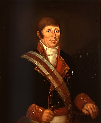
Francisco Mourelle de la Rúa, a notable Spanish navigator and naval officer, played a significant role in the exploration of the Pacific Ocean. During one of his voyages, he charted the island of Nanumea, naming it 'San Augustin,' and also passed by the island of Niutao, which he referred to as 'El Gran Cocal'. This exploration was part of broader Spanish efforts to map and understand the vast Pacific region, driven by both strategic and economic interests.
Mourelle's charting of these islands added critical information to European maps, which were crucial for navigation and colonial endeavors. The naming of these islands reflects the Spanish practice of ascribing new territories with names that had cultural and religious significance. This nomenclature also highlights the lack of indigenous consultation during this period of European exploration and expansion.
The impact of Mourelle’s journey extends beyond the immediate charting and naming. It contributed to European knowledge of the Pacific archipelago and facilitated further exploration. For the local inhabitants of these islands, such expeditions marked the beginning of increased foreign contact and subsequent changes driven by external influences.
Overall, Mourelle's endeavors are a notable example of the age of exploration's complexities, combining navigational achievements with the overtones of colonial ambitions. His contributions are part of the broader narrative of Pacific exploration and the resultant global cultural exchanges and transformations.
#Exploration #PacificHistory #ColonialImpact #FranciscoMourelle #TuvaluHistory #MappingTheWorld #MaritimeNavigation #MoofLife

Explore the Life Moments of