Roman Empire Territory in AD 390
Italy
Geography
Ancient Civilizations
6 min read
Updated By: History Editorial Network (HEN)
Published:
Updated:
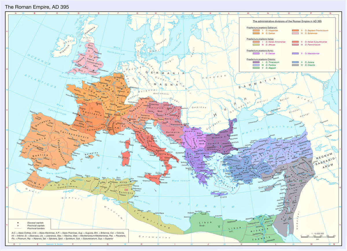
In AD 390, the Roman Empire spanned approximately 4.4 million square kilometers (1.7 million square miles), reflecting a reduced but still vast territorial reach compared to its peak of around 5 million square kilometers in AD 117 under Emperor Trajan. This contraction resulted from earlier strategic withdrawals, including the abandonment of Dacia in the late 3rd century and the loss of territories in Mesopotamia. At this time, the empire was ruled by Theodosius I, the last emperor to govern both the Eastern and Western halves before the permanent division in 395.
The empire’s administrative structure in 390 was highly organized, shaped by reforms introduced during the late 3rd and early 4th centuries, particularly under Diocletian and Constantine. It was divided into four major Praetorian Prefectures, each overseeing multiple dioceses and provinces. The Prefecture of the Gauls (Praefectura Praetorio Galliarum) governed the westernmost territories, including the Diocese of Britannia, which covered Roman Britain up to Hadrian’s Wall, and the Dioceses of Gallia and Viennensis, encompassing much of modern France, Belgium, and parts of western Germany. The Diocese of Hispania included the Iberian Peninsula and extended into North Africa through Mauretania Tingitana.
The Prefecture of Italy and Africa (Praefectura Praetorio Italiae et Africae) managed the central Mediterranean regions. This included the Diocese of Italia, covering the Italian peninsula and major islands such as Sicily, Sardinia, and Corsica. The Diocese of Africa administered the fertile North African provinces, including areas of modern Tunisia, eastern Algeria, and western Libya, which were key sources of grain supply for the empire.
In the eastern regions, the Prefecture of Illyricum (Praefectura Praetorio Illyrici) and the Prefecture of the East (Praefectura Praetorio Orientis) governed the Balkans, Greece, Anatolia, the Levant, and Egypt. These areas contained some of the empire’s most populous and economically productive provinces, including Egypt, which remained a crucial supplier of grain, and major urban centers such as Constantinople, Antioch, and Alexandria.
By AD 390, the Roman Empire remained a complex and interconnected political entity despite territorial losses. Its administrative system allowed for governance across diverse regions, languages, and cultures. However, underlying pressures, including military demands along frontiers and regional disparities in wealth and stability, continued to challenge imperial cohesion in the years leading up to its division in 395.
#RomanEmpire #TheodosiusI #AncientHistory #LateAntiquity #RomanAdministration #390AD
#mooflife
#MomentOfLife
#RomanEmpire
#Territory
#Ad390
#WesternRomanEmpire
#EasternRomanEmpire
Primary Reference
Roman Empire

Explore the Life Moments of